


Every skipper has asked it on the pontoon. The forecast says south-westerly, force 4, and you want to know where people actually go on a day like this: which anchorage holds them, which way they head, where nobody bothers.
The answer usually lives in the heads of the people who’ve sailed there for twenty years. Saltlog’s heat map is our attempt to put it on a chart, built from the passages people really logged, not from guesswork.
What the map shows
The heat map lives in Explore and draws three things:
- Trips: a fine line for every passage. One line is faint; where many boats went the same way, the lines build into a strong band.
- Anchor: a dot for each time someone dropped the hook.
- Mooring: a dot for each time someone picked up a buoy.
Below the map sits a compass. Tap a wind direction and a strength, and the map redraws with only the passages and stops made in that wind. Tap Right now and it sets today’s wind for you.
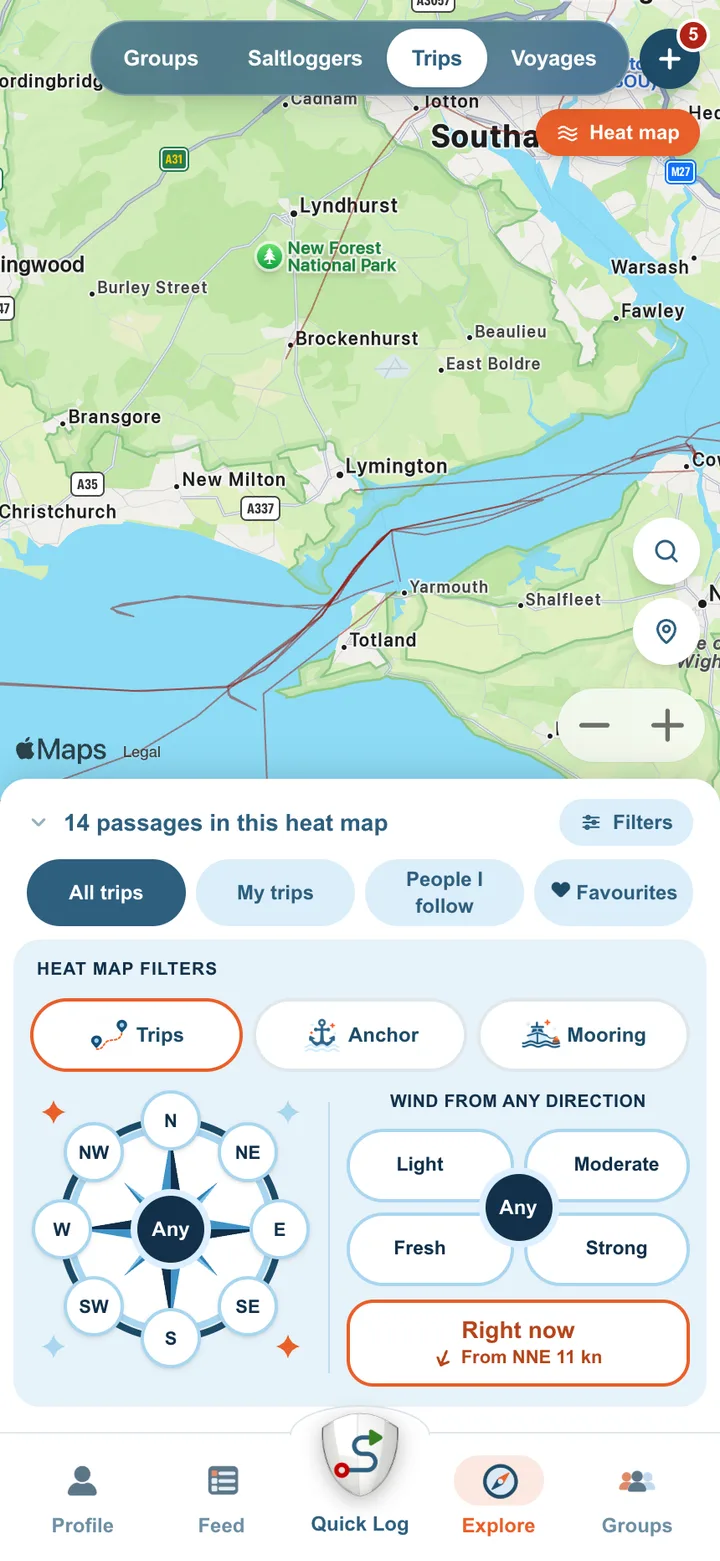
It shows where boats went. That’s all it claims, and it’s why it’s useful: it’s what people did, not what someone thinks they should do.
Why it needs your log
Here’s the honest part: the map is only as good as the boats on it. In a busy harbour it fills quickly. Somewhere quieter, and in an unusual wind, it may show very little at first.
Every trip you log adds a line, and every stop you tag as Anchor or Mooring adds a dot. Your own log stays yours: it’s your record first. But each one also makes the map a little more useful for the next skipper choosing where to go.
What we never show
A map built from people’s trips has to protect the people. So:
- No one boat stands out. An area appears only once at least three different boats have been there in those conditions. A lone line or a single anchoring never shows.
- Your home stays home. The start and end of every track are left off, so no line leads back to your berth or your house.
- Anchor and mooring dots are placed in the area, not on the spot. They show that boats lay somewhere around there, never exactly where you lay.
- Private means private. Trips you mark Private are left out entirely.
- No names. The map shows lines and dots, never who made them.
Coming soon: the tide
Wind is only half the story. Ask anyone who sails out of a tidal harbour and they’ll tell you the tide decides more than the forecast does. From Poole, an ebb tide suits a passage west, and a flood suits one east.
So the next filter is a tide slider. Slide it to a state of the tide, two hours after High Water say, and the map shows where boats went when they left within an hour of it. Pair it with the compass and you can ask the question skippers really ask: where did boats go on the ebb, in a westerly?
It’s coming soon, once there are enough logged trips behind it. Wind, strength and tide together cut the map into fine slices, and a slice with only one or two boats in it tells you nothing. We’d rather switch it on when it has something real to show.
The questions after that
Further out, these are the questions we’d like the map to answer, once enough boats have logged enough passages to answer them honestly:
- Where should I go today?Not every trip has a destination. Given today’s wind and tide, where did boats go on days like this, and when did they come home?
- When do people leave for somewhere further? For a longer passage, when did boats set off, and when did they pass the headland that matters?
We won’t put dates on these. They’ll come when the logs are there to make them true.
What it isn’t
The heat map isn’t advice, and it isn’t for navigation. A dense cluster of anchor dots means boats lay there in that wind. It doesn’t mean the holding is good today, or that it suits your boat, your draught or your crew. Use it the way you’d use a chat on the pontoon: as a starting point, alongside the forecast, the almanac, the chart and your own judgement.
Every log adds a line.
The next time you go out, start Quick Log and tag your stops. Your logbook gets the full record of your day. The map gets one more line, and the next skipper standing on the pontoon gets a slightly better answer.
See you on the water.